


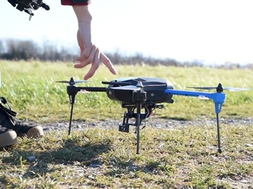
The Federal Aviation Administration is launching “Phase 2” of its BEYOND drone testing program – doubling the program’s current size by selecting up to eight additional state, local, tribal, and territorial entities to serve as lead participants for various drone-related initiatives.
[Above photo by FAA]
The expansion builds on the success of two programs established during the first Trump administration: the Unmanned Aircraft Systems Integration Pilot Program, launched in 2017, and BEYOND Phase 1, which began in 2020. The BEYOND program succeeded the Integration Pilot Program, FAA noted.

During BEYOND Phase 1, participants logged more than 70,000 flights, including more than 48,000 beyond visual line of sight or BVLOS operations, FAA said, and so far the program has “generated critical real-world operational and safety data” for its BVLOS rulemaking effort – begun in 2025 – as well as helped move drone regulation away from case-by-case approvals toward performance-based standards.
“As drone technology continues to advance, the FAA is focused on building a regulatory framework that is safe, scalable and grounded in real-world data,” said Bryan Bedford, FAA administrator, in a statement. “Phase 2 of BEYOND will expand the partnerships and operations needed to address remaining challenges in beyond visual line of sight operations, public safety missions, on-airport operations and other complex airspace environments.”
Several state departments of transportation have played critical roles within Phase 1 of the BEYOND program, including the Kansas Department of Transportation, the North Carolina Department of Transportation, and the North Dakota Department of Transportation.
Other state DOTs are also testing drones across a wide variety of applications.
For example, in 2025, the Colorado Department of Transportation successfully tested a new $800,000 Remote Avalanche Control System on the east side of the Eisenhower Johnson Memorial Tunnels, marking what the agency describes as “a major step forward” in modernizing avalanche mitigation operations along the I-70 Mountain Corridor.
The newly installed Wyssen Avalanche Control system allows Colorado DOT’s Winter Operations Team to perform avalanche mitigation work eliminating the need for the long-standing World War II-era artillery previously used to clear snowpack in this area. By operating remotely, crews can safely conduct mitigation any time, day or night, while significantly reducing safety risks and traffic impacts for the traveling public, the agency said.
Concurrently, the Utah Department of Transportation is using aerial drones and Light Detection and Ranging or LiDAR technology to monitor two 100-plus-year-old stone arches that span State Route 12 or SR 12 in southern Utah to prevent erosion and potential damage to vehicles. And in February 2024, several state agencies in Alaska collaborated on a major test of drone-based avalanche mitigation technology; a system that uses Unmanned Aerial System or UAS craft to place and then remotely trigger explosives to create controlled avalanches in order to protect transportation infrastructure.
 Nation
AASHTO Comments on Federal Revision of Water Rules
October 16, 2026 Nation
