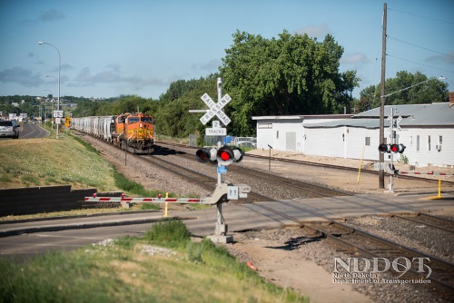
The U.S. Department of Transportation’s John A. Volpe National Transportation Systems Center issued a report on January 17 touting the use of unmanned aerial vehicles – known as UAVs or drones – by the Federal Railroad Administration to produce accurate 3-D models of high-profile grade crossings.
[Above photo by the North Dakota DOT]
Volpe’s report recommended that FRA pursue the development of a software tool that can analyze three-dimensional models of railroad grade crossings to produce a single number: the inches of ground clearance required for a vehicle with a 30-foot wheelbase to safely traverse a grade crossing.

In much the same way drivers are warned of a low bridge by the posted height, Volpe suggested to FRA that drivers of trucks and buses should be warned of “humped crossings” by having the inches of required ground clearance posted.
While drone-based “photogrammetry” offers a cost-effective way to collect crossing data, a software tool to analyze those models to produce the “inches of ground clearance” number does not yet exist, Volpe said, so one needs to be developed.

As a final step – once that ground clearance data is obtained – the report recommended that FRA work with the Federal Highway Administration to amend the Manual on Uniform Traffic Control Devices for Streets and Highways or MUTCD to make posting the required clearance at high-profile crossings part of the standard notification to drivers.
FHWA updated part of the MUCTD last December to allow for the optional use of red-colored pavement to enhance the conspicuity of station stops, travel lanes, or other locations in the roadway that are reserved for exclusive use by public transit vehicles or for multi-modal facilities where public transit is the primary mode of transport.
 Nation
AGC Survey: Highway Work Zone Crash Risks Rising
May 22, 2026 Nation