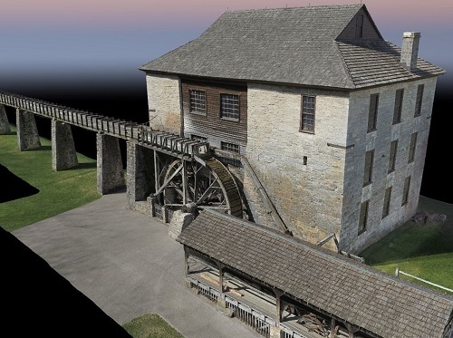
The Indiana Department of Natural Resources recently called upon the Indiana Department of Transportation for help “mapping” a historic water-powered grist mill at Spring Mill state park in Mitchell, IN, prior to the structure’s renovation this fall.
[Above image via INDOT]
The historic grist mill is located in the state park’s Pioneer Village – founded in 1814 – which contains 20 historic buildings to explore. The centerpiece is the spring-fed, three-story limestone grist mill, built in 1817, that still grinds corn today (though only for demonstration purposes) to produce cornmeal. INDOT noted that the last renovation of this grist mill occurred in 1930.
INDOT’s Land & Aerial Survey Office collected aerial imagery, light detection and ranging or LiDAR data, and other information on the grist mill via drone to create a three dimensional or 3D rendering of the building and water flume, including a fly-through video; a scaled and georeferenced point cloud of the mill building and water flume; and a publicly sharable link to an online geographic information system that features the 3D rendering and panoramic images.
“They wanted the data for historical documentation and possible public outreach,” noted Adam French, INDOT’s aerial geomatics coordinator, in a blog post. “This was a fun and educational project, giving us the opportunity to utilize several of our sophisticated tools to complete the mission.”
He noted that INDOT’s unmanned aircraft system used a high-quality camera for ground photos and a high-speed 3D laser scanning system for ground-based LiDAR scans.
“This project served as a testbed to combine and analyze many of the innovative technologies our office has available,” added Eric Banschbach, manager of the INDOT Land & Aerial Survey Office. “That includes unmanned aerial systems, high-resolution imagery, both aerial and terrestrial LiDAR scanning, and GPS.”
State departments of transportation are deploying drones in a wide variety of ways, including everything from inspecting infrastructure to enhancing highway incident response efforts.
For example, in May, the Alaska Department of Transportation & Public Facilities and Frontier Precision began testing a DJI M30 drone and DJI Dock system for avalanche hazard detection operations for state roadways, among other applications.
The agency said the docking station allows the drone to automatically launch and land from a fixed location. It also provides the drone with the ability to recharge its batteries and swap payloads, making it an ideal solution for long term and frequently reoccurring operations in remote and challenging environments.
Meanwhile, in the Iowa City area, the Iowa Department of Transportation is working with its “Highway Helper” contractor, Autobase, to test the use of drones to help clear highway incidents faster so traffic can get moving normally again.
The North Carolina Department of Transportation is doing something similar. In February 2022, the agency began testing a “tethered drone” system in conjunction with the agency’s highway patrol service to improve safety on North Carolina roadways.
NCDOT’s incident management assistance patrol or IMAP and its Division of Aviation tested drones tethered to specific IMAP vehicles to help responders assess incidents, provide situational awareness to NCDOT’s Statewide Transportation Operations Center or STOC and Traffic Management Centers or TMCs, and assist with overall traffic management of the incidents.
The NCDOT also began using drones in 2021 to help conduct bridge inspections. A waiver granted to the agency in 2020 by the Federal Aviation Administration allows NCDOT to operate drones beyond visual line of sight when inspecting bridges – letting the operator fly the drone around pillars, between girders, and even inside columns.
 States
RIDOT Wraps I-95 Providence Viaduct Northbound Project
January 30, 2026 States

