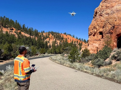
The Utah Department of Transportation is using aerial drones and Light Detection and Ranging or LiDAR technology to monitor two 100-plus-year-old stone arches that span State Route 12 or SR 12 in southern Utah to prevent erosion and potential damage to vehicles.
[Above photo by Utah DOT]
Dubbed the “Red Canyon Arches,” those two stone landmarks were recognized in 1925 as the original entrance to Utah National Park, which is now called Bryce Canyon National Park. However, the natural process of erosion causes stone from the arches to fall on SR 12 occasionally – creating a safety issue for motorists.
For that reason, Utah DOT initiated a project six years ago to use a variety of technologies to monitor the stone arches more closely. For phase one of the project, kicked off in 2019, Utah DOT said it used several sensors, drones, and a stationary LiDAR tool to collect data on the SR 12 arches, located between Panguitch and Bryce Canyon.
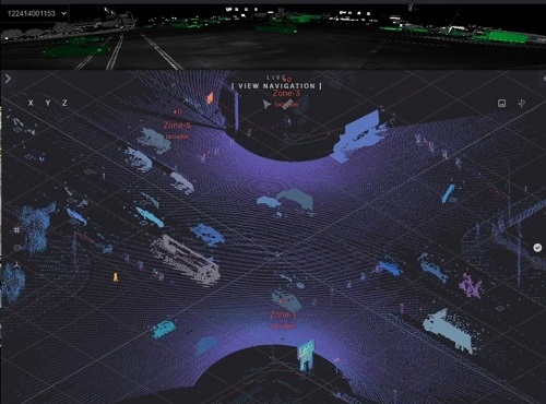
The drone captured thousands of two-dimensional or 2D photos that were then turned into 3D recreations of the arches, while the LiDAR device used eye-safe laser beams to scan through and underneath the arches. Utah DOT engineers then combined the data to track displacement, rockfall, deformation, or any other areas of concern.
[Editor’s note: Utah DOT is no stranger to the use of either technology. For example, it used LiDAR in 2024 to help improve safety at intersections, specifically for pedestrians and bicyclists.]
This spring, the project secured additional funding to start phase two of the project, where crews will install additional sensors in the arches at crucial locations as the previously installed sensors are damaged or not providing sufficient data. The agency added that it hopes to install the new sensors this fall, after summer tourist traffic has decreased.
“These archways are icons in our state, and we want to make sure we’re doing what we can to preserve them for the future,” noted Kirk Thornock, Utah DOT’s Region Four director, in a statement. “By using technology like LiDAR and these new sensors, we are able to keep a close watch on these treasured resources so that families, tourists, and locals can continue to be inspired by the stunning and unique nature that exists in our state.”
With a larger collision occurring in 2019 and other smaller scrapes happening in recent years, the arches and their “shotcrete” – a concrete mix sprayed onto the surface of the original rock to preserve the arches – have experienced increased damage. These incidents prompted an increased effort to monitor the arches, instead of typical biennial assessments, with the agency prioritizing placement of the sensors in non-obtrusive areas so that data collection can occur with minimal impact to the area’s natural beauty.
“We believe good roads cost less,” emphasized James Corney, Utah DOT structures project engineer. “That’s why we’re prioritizing extra monitoring of these arches — because preserving and maintaining our roads instead of responding reactively to larger problems costs the taxpayer less in the long run.”
 States
Louisiana Celebrates Completion of $30M Bridge Project
February 20, 2026 States