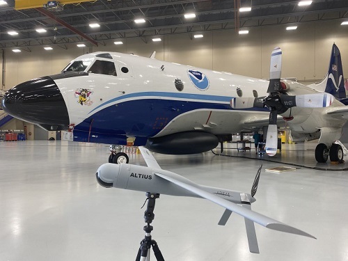
The National Oceanic and Atmospheric Administration (NOAA) is working to improve its hurricane forecasting capabilities by using a variety of aerial and ocean-based drones; using those uncrewed systems and other tools to gather data at different levels of the ocean and the atmosphere to improve the agency’s understanding of how storms form, build, and intensify.
[Above photo by NOAA]
Together with NOAA Hurricane Hunter aircraft carrying sensors, the agency said in a statement that such drone-based data could help “paint a clearer picture” for scientists of the forces that drive hurricanes.
NOAA added that its newest hurricane modeling technology – called the Hurricane Analysis and Forecast System or HAFS and based in part of drone-gathered data – goes into operation this season; a model jointly developed, tested, and evaluated by the NOAA Atlantic Oceanographic & Meteorological Laboratory, NOAA National Weather Service’s National Centers for Environmental Prediction, the NOAA Cooperative Institute for Marine & Atmospheric Studies, and the University of Miami.
NOAA added that, during the spring, it tested a small uncrewed aircraft system from Black Swift Technologies called the S0; a smaller, more lightweight uncrewed aircraft system than what the agency has used in the past with sensors that measure temperature, pressure and humidity.
NOAA will also test the use of other small uncrewed aircraft systems, such as the Andruil–Altius 600 – flown into the eye of Hurricane Ian in September 2022 – and Dragoon, which offers a land-launched small uncrewed aircraft system.
NOAA will also deploy Streamsondes, a new lightweight weather “dropsonde” – small instruments that collect profiles of atmospheric pressure, temperature, relative humidity, wind speed, and wind direction as they descend through the atmosphere – developed by Skyfora.
These new drone-delivered dropsondes will join more “traditional” sensors – such as Airborne Expendable BathyThermographs – that NOAA has deployed from piloted aircraft for many years. Airborne Expendable BathyThermographs, by the way, are small probes released from aircraft that measure ocean temperature as a function of depth as they descend through the water column.
Finally, for the third year in a row, NOAA will deploy 12 Saildrones to help with hurricane forecasting in the Atlantic Ocean, Caribbean and Gulf of Mexico – uncrewed surface ocean observation platforms powered by solar, wind, and wave energy that track hurricane development.
The instruments carried by those drone platforms provide information about the ocean and atmosphere, including sea surface temperature, salinity, surface air temperature, humidity, pressure, wind direction and speed, and wave height.
NOAA also plans to deploy some 20 to 30 underwater “gliders” as well – autonomous platforms that profile water properties in nearshore and open ocean environments, providing temperature and salinity observations to depths of 1000 meters, which is slightly more than a half mile, in areas where hurricanes are known to intensify and/or weaken.
The agency noted it has been monitoring ocean conditions using gliders for more than 10 years.
 Top Stories
USDOT Makes $1.5B Worth of BUILD Grants Available
December 19, 2025 Top Stories

