


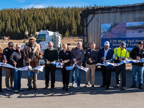
The Colorado Department of Transportation recently completed the I-70 West Vail Pass Auxiliary Lanes project; a six-year effort that built not only a new eastbound climbing lane, but the state’s first-of-its-kind passive avalanche mitigation system and five new wildlife underpasses.
[Above photo by Colorado DOT]
The agency said funds for the $340 million project came from a $60.7 million federal Infrastructure for Rebuilding America or INFRA grant awarded in June 2020; Colorado DOT state matching funds; and allocations from the Federal Highway Administration. Key participating agencies and stakeholders include Colorado DOT, FHWA, Kiewit Infrastructure Co., the U.S. Forest Service, Colorado Parks and Wildlife, Colorado Avalanche Information Center, Eagle County, Town of Vail, and the I-70 Coalition.
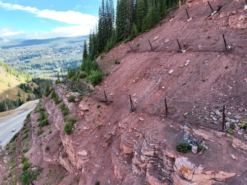
Stretching across 10 miles of challenging, high-elevation mountain terrain from the East Vail Interchange to the Vail Pass Rest Area, West Vail Pass is one of Colorado’s most critical and weather-impacted interstate corridors.
“Vail Pass presents some of the most challenging terrain on Colorado’s highway system,” said Shoshana Lew, Colorado DOT executive director, in a statement.
“All of the components of this project — from widened shoulders for emergency responders to cutting-edge avalanche mitigation improvements that will protect travelers and avoid road closures for avalanche control work — will make this corridor safer and more dependable,” she noted We appreciate all of the collaboration that got us to this milestone.”
The project’s improvements include:
- A new eastbound auxiliary lane: A continuous third eastbound climbing lane between Mile Point 187 and Vail Pass’s Summit at MP 190 that separates slow-moving heavy vehicles from lighter passenger traffic, reducing speed-differential crashes.
- Reconstructed bridges and curve realignment: Modernized dual bridges near MP 185 engineered with a 100-year service life, realigned to soften the sharp curves and shifted north to protect Polk Creek.
- Relocated Vail Pass Recreation Path: To make room for road improvements, the path was moved further south from the interstate lanes between MP 185 and MP 187, resulting in a safer, smoother experience for cyclists and trail users.
- U.S. Forest Service trailhead parking expansion: The Colorado DOT and U.S. Forest Service worked together to expand and improve the trailhead parking lot along Bighorn Road in East Vail. Built by beneficially repurposing excavated rock and soil from the highway corridor, the expanded lot improves recreation access to the popular Gore Lake and Deluge Lake trailheads while reducing parking spillover and pedestrian/vehicle conflicts along the adjacent Vail Pass Recreation Path.
- Passive avalanche and rockfall mitigation system: Installed in an area known as the “Narrows” near MP 186, this system allows Colorado DOT and the Colorado Avalanche Information Center to safely monitor and manage active avalanche paths limiting extended multi-hour closures and potential detours.
- Improved emergency truck ramp and containment: Reconstructed just east of West Vail at MP 182 with a straighter entry path to prevent runaway truck rollovers, featuring an integrated hazardous materials settlement basin to protect nearby Gore Creek and local water resources.
- Expanded commercial truck parking: New parking areas were built cost-effectively by repurposing excavated soil on site.
- Five wildlife underpasses & fencing: Five new wildlife underpasses – two large and three small-to-medium in size –plus exclusionary fencing between MP 187 and MP 190 help protect wildlife movement for high-elevation species including Canada lynx, elk, moose and deer. Altogether, those improvements are projected to cut wildlife-vehicle collisions by 80 percent to 90 percent in the areas.
- Sediment control and environmental stewardship: Upgraded Sediment Control Action Plan basins to trap winter traction sand and highway runoff before reaching Gore Creek and Polk Creek, preserving vital trout and insect habitats.
Additionally, project crews installed utility trenching and fiber-optic infrastructure to power the corridor’s Intelligent Transportation Systems – including variable speed limit signs, weather sensors, and automated traffic management – alongside extensive asphalt resurfacing engineered to withstand Vail Pass’s severe freeze-thaw cycles.
 States
FHWA, Georgia DOT Sign NEPA Agreements
November 20, 2026 States
