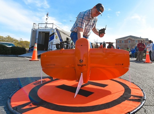
The Alabama Department of Transportation recently launched what it calls a “a groundbreaking new program” to formalize its use of Unmanned Aerial Systems (UAS) or drones in a variety of roles: from inspecting infrastructure to assisting with traffic management and disaster response.
[Above photo by Alabama DOT]
John D’arville, a 33-year agency veteran, is the new UAS Program Administrator for Alabama DOT and has been responsible for formalizing the department’s use of drones.
The agency noted in a statement that it uses drones primarily in two ways: sending them up to scope an area prior to new construction or development, particularly in areas that may not be accessible by foot, and helping monitor progress on infrastructure construction projects on a daily basis.
[Editor’s note: The video below explains how the Alaska Department of Transportation & Public Facilities uses drones to improve disaster response efforts, especially in rural areas of the state.]
Each drone flight requires at least two people to be on the ground, one to fly and one to monitor, the agency said – with those crew keeping drones within eyesight the entire time. Once the drones take images, they can upload them and make them available right away to crew leaders.
That gives construction teams the ability to see within hours what is going on–and possibly catch errors that need correcting–where before it could have taken days, D’arville said.
“This saves time and money and allows crews to focus on more important things,” added UAS Manager Jonathan Woodham.
Woodham oversees the day-to-day operations of the drone projects, and he said there is another benefit to the state: safety.
“They allow us to get information that we could normally get in other ways–but using a drone allows us to do it safer and more efficiently while getting a different viewpoint,” he explained. “You can see a project in a completely different light.”
Inspectors are now safer as they can stay more readily out of traffic, and motorists benefit as well because drones don’t require stoppage of traffic to use.
Drones are also allowing the agency to experiment with a method that provides a more efficient way to check the safety of bridges.
A specifically designed mapping drone will take footage of a bridge – getting within 6 inches of it – allowing Alabama DOT to then produce a three dimensional or 3D model of that bridge.
This will allow bridge inspectors to view all they need right from their desk – rather than having to travel there and back, the agency said.
“Sometimes a bridge might be two hours away, and this saves them four hours in travel time,” Woodham added. “This is an extremely good use of taxpayer money.”
Finally, drones also allow Alabama DOT to literally leave smaller footprints when it comes to the environmental impact of agency operations.
“We flew around an 800-acre wetland irrigation area for two hours versus stomping around it for days like we used to have to do,” D’arville said. “We still have boots on the ground, but it’s a more efficient way of getting data in users hands so they can make the decisions they need to make.”
Other state departments of transportation are also using drones in similar fashion across a wide array of agency operations.
For example, the Alaska DOT&PF recently highlighted how it uses strategic drone partnerships to boost its avalanche mitigation efforts so as to improve both highway safety and accessibility on a statewide basis.
Meanwhile, the Arizona Department of Transportation is using drones as an “aerial inspection tool” for its year-round maintenance program for 50 pump stations that remove storm runoff from many sections of Phoenix-area freeways.
The agency said its technicians now use a drone to look for cracks, leaks, worn parts or other problems within pump stations. The Arizona DOT added in a statement that the drone lets its crews examine areas that are difficult for them to access, including upper sections of pipes that lift stormwater from a pump station’s storage well.
Meanwhile, a Washington State Department of Transportation Tacoma-area maintenance is using drone technology that can remove graffiti from hard-to-reach places; applying paint from aerial positions to cover graffiti on bridge abutments and other types of transportation-related infrastructure.
Concurrently, this spring, the Minnesota Department of Transportation used drones for its “aerial mapping operations” in the northwestern part of the state; using the aerial devices to help create a record of existing infrastructure and landscapes along rights-of-way managed by the agency for transportation planning and highway design.
And in August 2023, the Georgia Department of Transportation began participating in a “drone as a first responder” or DFR program along a stretch of I-85.
 States
Serna Stepping Down as Secretary of NMDOT
February 13, 2026 States

