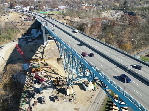
The Ohio Department of Transportation recently released the results of an 18-month study that examined how transportation investments can support economic growth and development statewide.
[Above photo by Ohio DOT]
The agency said it worked with the Governor’s Office of Workforce Transformation, the Ohio Department of Development, JobsOhio, and more than 500 elected officials, business leaders, and transportation and regional planning experts to identify transportation needs, opportunities, and concerns across the state.

“The goal is to help us understand how Ohio’s highways influence and support statewide economic growth and prioritize transportation projects, as funding is available,” said Governor Mike DeWine (R) in a statement. “Ohio’s economy is growing and to keep this momentum going, we must get people to work and deliver goods on time.”
The report identifies 72 congestion risk locations across the state, referred to as “hotspots,” and of those locations, all but 21 were already on Ohio DOT’s radar. The 51 projects already in the agency’s pipeline represent a total investment of $13 billion.
However, the Ohio DOT noted that $6.1 billion worth of the projects remain unfunded.
“Overall, most of Ohio’s major highway corridors are handling the needs of today and are expected to do so in the future, even if current population and economic growth trends accelerate,” added Pamela Boratyn, Ohio DOT director.
“However, we have identified congestion risks that could hinder future economic development,” she added. “This tool will assist Ohio DOT and local leaders in ensuring transportation is never a roadblock to economic opportunity.”
Boratyn also noted that the report focused on key “congestion risks” in seven geographic/economic regions across the state, with a particular focus on “interregional connections” – specifically examining how those corridors will meet travel needs over the next 10, 20, and 30 years. Those corridors are:
- Toledo – Columbus: This includes I-75, US 68, State Route 31 or SR 31, and US 23. It connects Northwest Ohio, including Toledo, with Central Ohio’s fast-growing Delaware and Union counties. It is also a critical link to Detroit and U.S.-Canada border crossings from Central Ohio, including the Gordie Howe International Bridge, which is expected to open later in 2025. The main recommendation is to improve US 23 between Waldo and I-270, but not the construction of an alternative freeway due to the cost as well as minimal travel time reductions from such a project.
- Sandusky – Columbus: This corridor includes SR 4, US 250, I-71, and US 23. It connects Sandusky and resort areas along Lake Erie with communities in Delaware and Franklin counties. Sandusky’s economy relies on tourism and manufacturing while the Delaware County economy is expected to continue to diversify. The study recommended evaluating potential improvements to SR 4 and US 250 such as widening narrow shoulders and adding turn lanes in rural areas.
- Columbus – Kentucky/West Virginia: This corridor includes US 23 and US 52 and connects Central Ohio with Southeast Ohio, Portsmouth, the Ohio River, West Virginia, and Kentucky. The priority recommendation is to initiate a feasibility analysis and initial project development activities that will position Ohio DOT to increase capacity and manage access on US 23 from I-270 to south of Circleville.
- Columbus-West Virginia: The US 33 corridor connects Central Ohio with Southeast Ohio, the Ohio River, and West Virginia, with the report recommending 29 safety improvements as well as more construction funding for existing agency projects on US 33 in Franklin and Fairfield counties.
- Cincinnati-Dayton: The I-75 corridor connects Dayton and Cincinnati, with the north end of the corridor serving the Dayton International Airport and Union Global Logistics Airpark at Dayton Airport, with many logistics-related businesses located nearby. The study recommended continuing to develop projects associated with the I-75/I-275 interchange and work with regional planning organizations to improve Cincinnati to Dayton corridor connections.
- Canton/Youngstown-West Virginia/Pennsylvania: This corridor includes US 30 and SR 11 and connects Northeast Ohio with West Virginia and the Pittsburgh metropolitan area in Pennsylvania. The study recommended addressing local safety concerns and updating interchanges on US 30 in Stark and Columbiana counties.
 States