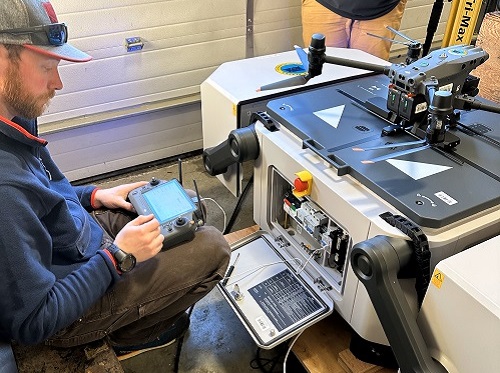
The Alaska Department of Transportation & Public Facilities and Frontier Precision are currently testing a DJI M30 drone and DJI Dock system for avalanche hazard detection operations for state roadways, among other applications.
[Above photo via the Alaska DOT&PF]
The agency said the docking station allows the drone to automatically launch and land from a fixed location. It also provides the drone with the ability to recharge its batteries and swap payloads, making it an ideal solution for long term and frequently reoccurring operations in remote and challenging environments.
“We are thrilled to have partnered with Frontier Precision and DJI on this test of UAS integration,” said Ryan Marlow, UAS coordinator for Alaska DOT&PF’s statewide aviation group, in a statement. “This innovative new solution has the potential to revolutionize the way we conduct long-term drone operations, particularly in Alaska’s more remote areas.”
During the test, the drones captured high-resolution aerial imagery of an area in Juneau known for frequent avalanches, which will be used to support the agency’s efforts to improve safety and conduct avalanche hazard reduction in the area. The DJI M30 Docking Station also allowed the drones to cover a large area quickly and efficiently, without the need for multiple launches and landings.
The successful testing shows that unmanned aircraft systems or UAS can contribute significantly to enhancing safety across Alaska by providing advanced monitoring and inspection capabilities, the agency added.
State departments of transportation across the country are currently using and/or testing drones across a variety of applications.
For example, in the Iowa City area, the Iowa Department of Transportation is working with its “Highway Helper” contractor, Autobase, to test the use of drones to help clear highway incidents faster so traffic can get moving normally again.
The North Carolina Department of Transportation is doing something similar. In February 2022, the agency began testing a “tethered drone” system in conjunction with the agency’s highway patrol service to improve safety on North Carolina roadways.
NCDOT’s incident management assistance patrol or IMAP and its Division of Aviation tested drones tethered to specific IMAP vehicles to help responders assess incidents, provide situational awareness to NCDOT’s Statewide Transportation Operations Center or STOC and Traffic Management Centers or TMCs, and assist with overall traffic management of the incidents.
In August 2022, the Ohio Department of Transportation is playing a key role in developing technology to keep airspace safe for both “manned” and “unmanned” aircraft, while also establishing an advanced air mobility or AAM framework for autonomous aircraft operation statewide.
At low altitudes, detecting air traffic – including unmanned drones – with traditional radar is much more difficult due to the presence of ground obstructions such as trees, houses, cars, and other low-flying objects such as birds and insect swarms.
As a result, Ohio DOT’s Office of Statewide Planning and Research along with its DriveOhio division has been working with the Federal Aviation Administration, the Ohio Unmanned Aircraft Systems Center, and Ohio State University, and industry to develop and deploy a “detect and avoid” system.
That system would track drones as a “public service” and keep them from colliding with aircraft that operate at lower altitudes like medical helicopters or crop dusters, the agency said.
Meanwhile, the Michigan Department of Transportation is one of several state agencies that is working work with the Ontario Vehicle Innovation Network or OVNI to explore operating small drones beyond the line of sight of a pilot for just-in-time deliveries, medical transport needs, and other “small-scale” deployments.
The aeronautics division of the Massachusetts Department of Transportation recently began working with drone provider Skyports to demonstrate how drone services could link communities across the Cape Cod region.
MassDOT said it is investigating the use of drones as a solution to connecting its remote communities to everyday services such as healthcare and logistics, and in particular is looking to develop a capability to provide emergency medical delivery after storms or other natural disasters.
 States
RIDOT Wraps I-95 Providence Viaduct Northbound Project
January 30, 2026 States

