
The Hawaii Department of Transportation recently launched two new free airport wayfinding mobile applications designed to make the airport experience less stressful and more enjoyable for travelers.
[Above photo by Hawaii DOT]
The HNL Airport app for the Daniel K. Inouye International Airport and LIH Airport app for the Lῑhuʻe Airport offer travelers a new mobility tool to navigate the airport terminal, the agency said; apps that include links to the respective airport’s flight information and airport website which features information about other airport services and guidance.
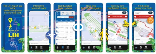
Hawaii DOT said in a statement that both apps – which can be downloaded for free from Google Play and Apple Store – use blue dot wayfinding technology similar to the blue circles on online navigation maps such as Google Maps or Apple Maps. A pulsing blue dot estimates the user’s physical location on the airport map to assist in navigating through the terminals, the agency said.
Hawaii DOT added that app users can also search for their points of interest and navigate their way throughout the airport, including check-in, baggage claim, agricultural inspection stations, security checkpoints, departure gates, food and beverage options, retail shops, lounges, restrooms, ground transportation, and more.
The HNL app also has an online parking count feature, refreshed every 10 minutes per parking structure to display the number of available slots before travelers arrive at the airport, the agency pointed out.
Hawaii DOT noted that future app enhancements include adding the location of the Skyline Lelepaua station, which opens later this year – with an app for Kahului Airport (OGG) being planned.
 States
Kansas DOT Helps Host ‘Drive To Zero Day’ Event
March 13, 2026 States